A new NERDS co-authored paper is out open-access in the Journal of Spatial Information Science (JOSIS): A shape-based heuristic for the detection of urban block artifacts in street networks, by Martin Fleischmann & Anastassia Vybornova.
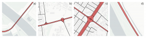
a) Bridge, Amsterdam; b) Roundabout, Abidjan; c) Intersection, Kabul; d) Motorway, Vienna. Polygons classified as face artifacts are shown in red, and the OSM street network (without service roads) is shown in black. Face artifacts are polygons enclosed by street network geometries (in the case of OSM, lane centerlines) that do not represent morphological urban blocks, but instead are a result of detailed transportation-focused mapping of the streetscape. Map data (c) OpenStreetMap contributors (c) CARTO
We propose a cheap computational heuristic for the identification of ‘face artifacts’, i.e., geometries that are enclosed by transportation edges but do not represent urban blocks. Sounds cryptic? Just check out the picture – the artifacts (in red) might be painfully familiar to anyone who has worked with street network data. Our proposed heuristic, implemented open-source in momepy, is the first step towards a fully automated street network simplification workflow. Next steps coming up – stay tuned!