Category Archives: Project

Paper & Viz: Analysis of Denmark’s whole bicycle network

Today we published the paper which marks the Grand Finale of Ane’s PhD, which she will defend this thursday, May 22nd, in Auditorium 2 at ITU: https://en.itu.dk/Research/PhD-Programme/PhD-Defences/PhD-Defences-2025/May/Ane-Rahbek-Vier_

Her thesis is “Network Analysis of Denmark’s Bicycle Infrastructure: Data & Infrastructure for All?”, of which an important part is the paper:

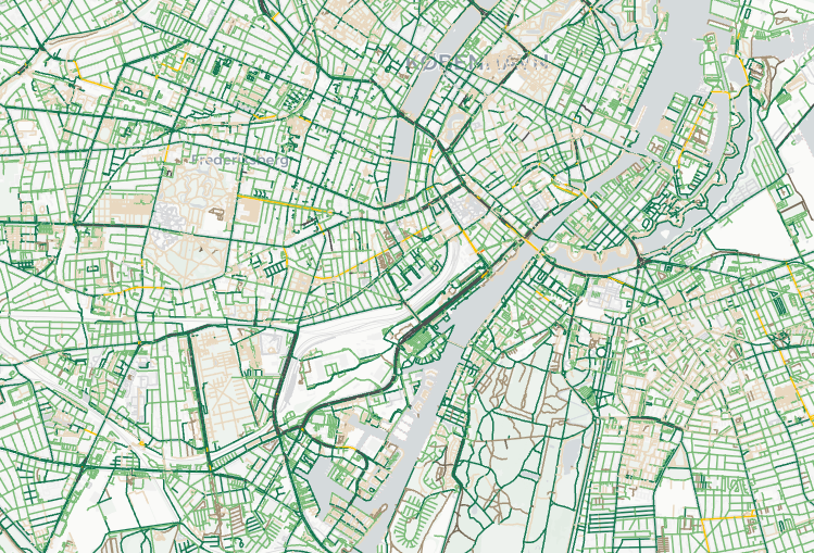
Network Analysis of the Danish Bicycle Infrastructure: Bikeability Across Urban–Rural Divides, by A.R. Vierø and M. Szell, published in Geographical Analysis

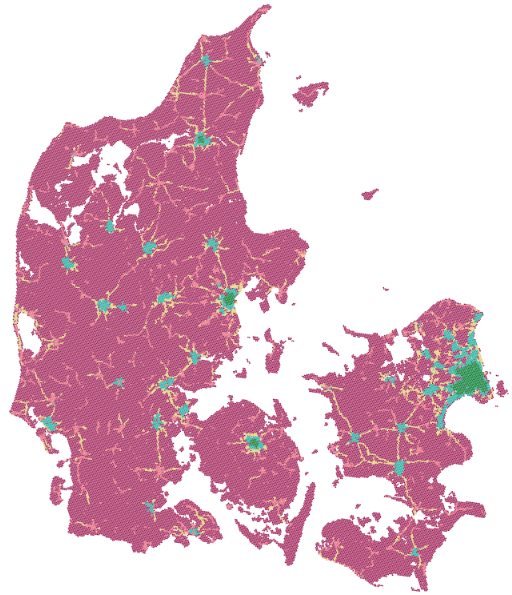
To bridge the gap between urban and rural cycling research, we analyze the bicycle network of Denmark, covering around 43,000 km2 and nearly 6 million inhabitants. We divide the network into four levels of traffic stress and quantify the spatial patterns of bikeability based on network density, fragmentation, and reach. We find that the country has a high share of low-stress infrastructure, but with a very uneven distribution. The widespread fragmentation of low-stress infrastructure results in low mobility for cyclists who do not tolerate high traffic stress. Finally, we partition the network into bikeability clusters and conclude that both high and low bikeability are strongly spatially clustered. Our research confirms that in Denmark, bikeability tends to be high in urban areas. The latent potential for cycling in rural areas is mostly unmet, although some rural areas benefit from previous infrastructure investments. To mitigate the lack of low-stress cycling infrastructure outside urban centers, we suggest prioritizing investments in urban–rural cycling connections and encourage further research in improving rural cycling conditions.

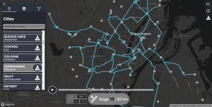
With the paper comes an interactive visualization of the whole bicycle network of Denmark! Check it out at: bikenetwork.dk

This achievement also marks the conclusion of all our “deliverables” for the Vejdirektoratet grant by the Danish Ministry of Transport which financed Ane’s Phd.

If you are around ITU, don’t miss Ane’s defense on thursday!

Release of GrowBike.Net to explore growing urban bicycle networks

Recently we released GrowBike.Net, accompanying our preprint “Growing Urban Bicycle Networks“. The interactive data visualization platform was developed by NERDS Master students Cecilia Laura Kolding Andersen and Morten Lynghede as part of their thesis “Developing an Interactive Visualization of Bicycle Network Growth” with Michael Szell.

GrowBike.Net lets you explore how to grow bicycle networks from scratch in 62 cities worldwide. Choose a city and grow the bike network, connecting places efficiently step by step.

The growth process creates a cohesive bicycle network – something that every modern city should have. Studying these synthetic networks informs us about the geometric limitations of urban bicycle network growth and can lead to better designed bicycle infrastructure in cities. GrowBike.Net also allows to compare the grown networks with your city’s existing bicycle network.

Although our approach here is not yet aiming to provide concrete urban design solutions, it could be useful for planning purposes for easily generating an initial vision of a cohesive bicycle network – to be re-fined subsequently.

The platform also features a media page where over 1000 videos and plots can be downloaded: http://growbike.net/download

Have fun exploring growing bike networks in your city!

Explore multilayer networks in Virtual Reality

Click for a video demo of MNET-VR

Click for a video demo of MNET-VR

Multilayer networks are an increasingly popular way to model complex relations between various types of entities and they have been applied to a large number of real-world data sets. Their intrinsic complexity makes the visualization of this type of network extremely challenging and still an open research area. To help the visual exploration of complex multilayer network structures, today we are releasing MNET-VR. MNET-VR is the output of a research project carried on with Leonard Maxim and supported by the Digital Design Department. MNET-VR explores the potential of Virtual Reality to visualize this type of network structure.

MNET-VR offers basic functions to visualize and filter multilayer network structures. MNET-VR does not offer, at this stage, the possibility to manipulate the network layout. A proper 3D layout of the network can be obtained through the R package multinet. While its primary goal is to explore multilayer networks, MNET-VR can also be used to visualize single layer networks using igraph and multinet. The export of of the files for visualization is done through two simple R functions that we make available on the website. MNET-VR is designed for Oculus Rift/Oculus Quest with Link.